At NV5, we provide innovative solutions to enhance transportation infrastructure through advanced data acquisition and analysis. Our expertise in Thermal Infrared Bridge Assessments, Mobile Lidar Mapping, and Comprehensive Transportation Asset Management enables clients to make informed, data-driven decisions.
Smart Solutions for Smarter Infrastructure
Thermal Infrared Bridge Assessments
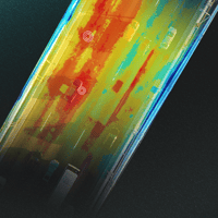
Detect hidden structural issues with our thermal infrared technology, identifying moisture infiltration, delamination, and insulation failures without costly closures. Our non-invasive assessments ensure safer, longer-lasting bridges.
Thermal Infrared Bridge Assessments
Detect hidden structural issues with our thermal infrared technology, identifying moisture infiltration, delamination, and insulation failures without costly closures. Our non-invasive assessments ensure safer, longer-lasting bridges.
Mobile Lidar Mapping
Capture high-precision spatial data using our Mobile Lidar Mapping technology. Mounted on vehicles, boats, or ATVs, our system delivers unmatched accuracy for surveying, engineering, and infrastructure management.
Why Choose NV5?
Proven Expertise:
With years of experience in infrastructure technology, we deliver data-driven solutions that meet industry standards.
Innovative Technology:
We utilize the latest advancements in thermal imaging, lidar, and geospatial analytics for unparalleled accuracy.
Seamless Integration:
Our cloud-based asset management solutions transform complex data into actionable insights.
Cost-Effective Solutions:
Our services reduce downtime, improve safety, and optimize maintenance investments.


Lifecycle Asset Monitoring & Predictive Analytics
Our asset management solutions go beyond data collection—we provide ongoing monitoring and predictive analytics to ensure transportation infrastructure remains in peak condition. By leveraging machine learning algorithms and historical data trends, we help agencies anticipate maintenance needs before failures occur, minimizing disruptions and reducing long-term costs.
Data Integration & Cloud-Based Access
NV5’s transportation asset management solutions seamlessly integrate with existing infrastructure databases, allowing for real-time data access through cloud-based platforms. This ensures that all stakeholders—from engineers to decision-makers—can collaborate efficiently with up-to-date insights, fostering a more proactive approach to infrastructure planning and maintenance.
Sustainable Infrastructure Planning
We incorporate sustainability-focused solutions into our asset management strategies, helping agencies prioritize eco-friendly materials, energy-efficient designs, and climate-resilient infrastructure. By aligning with federal and state sustainability goals, NV5 supports the long-term resilience and environmental responsibility of transportation networks.
Explore Our Success in Illinois
NV5 partnered with Winnebago County to enhance transportation asset management, leveraging cutting-edge lidar and thermal imaging technology to assess and maintain critical infrastructure. Our work helped streamline data collection, improve maintenance planning, and optimize long-term asset investments.
Discover how NV5’s innovative solutions transformed Winnebago County’s transportation network.
Key Achievements:
-
Comprehensive Asset Inventory:
Developed a complete digital record of roads, bridges, and transportation assets. -
Predictive Maintenance Planning:
Enabled proactive infrastructure repairs and budget forecasting. -
Enhanced Public Safety:
Identified critical maintenance needs before they became safety hazards.

Comprehensive Infrastructure Lifecycle Solutions
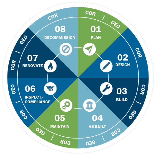
At NV5, we support the full lifecycle of transportation infrastructure, ensuring efficiency, safety, and sustainability at every stage:
Plan:
Utilize lidar, thermal imaging, and geospatial analysis to develop accurate, cost-effective infrastructure strategies.
Build:
Ensure precise execution during construction with real-time data integration, reducing errors and optimizing resources.
Maintain:
Predictive analytics and monitoring help address issues proactively, minimizing costs and disruptions.
Inspect & Ensure Compliance:
Advanced thermal infrared and lidar inspections detect structural issues, ensuring regulatory compliance and safety.
Renovate & Upgrade:
Data-driven insights prioritize and execute infrastructure upgrades efficiently, modernizing assets for long-term investment.
Hear From Our Clients
"NV5's advanced data solutions and the Project Asset Inventory Dashboard have streamlined our processes and enhanced our decision-making. Their detailed and accurate data collection has made a significant difference for Winnebago County."
.png)
Thermal Infrared Bridge Assessments
Bridge deterioration can lead to costly repairs and safety hazards. NV5’s Thermal Infrared Bridge Assessments provide a non-invasive, highly accurate method for detecting structural issues before they become critical. Using advanced infrared imaging, we identify hidden defects such as moisture infiltration, delamination, and insulation failures—without requiring lane closures or disruptive testing methods. For one project, NV5 collected data from over 41 bridges in a single afternoon using a fixed-wing platform.
Key Benefits:
-
Early detection of subsurface bridge defects
-
Non-contact, rapid assessment with minimal traffic disruption
-
Supports proactive maintenance planning and cost savings
.png)
.png)
Mobile Lidar Mapping
Accurate spatial data is essential for effective infrastructure management. NV5’s Mobile Lidar Mapping technology collects high-resolution, geospatial data in real-time, allowing for precise mapping of roads, bridges, and transportation assets. Mounted on vehicles, boats, or ATVs, our lidar system captures millions of data points per second, delivering a comprehensive 3D model of the surrounding environment. NV5's Mobile Lidar maps over 1,000 points/m² at speed with high vertical accuracy, even under bridges.
Applications:
-
Roadway and corridor mapping for engineering and planning
-
Bridge clearance and vertical clearance surveys
-
Floodplain modeling and environmental assessments
Comprehensive Transportation Asset Management
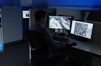
Effective infrastructure management requires a data-driven approach. NV5’s MERGE program integrates lidar, thermal, and satellite imagery into a centralized platform, enabling clients to efficiently monitor and maintain assets. Our cloud-based GIS tools support predictive maintenance, long-term planning, and budget optimization.
Features:
-
Cloud-based GIS integration for real-time asset tracking
-
Predictive analytics to prioritize maintenance needs
-
Seamless data fusion from multiple imaging technologies
-
Digitally twin assets for real-time insights and optimization
Ready to Transform Your Infrastructure?
NV5’s advanced technology and data-driven insights are revolutionizing transportation asset management. Whether you need bridge assessments, lidar mapping, or full-scale asset management, we have the expertise to help.
